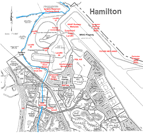
A Brief Guide to Hamilton Toxics Map
Basewide Concerns: Historic contamination of DDT’s throughout the property; groundwater contamination and inadequate monitoring; transportation of toxics off site by groundwater, surface water, and stormwater; lack of hydro geologic studies to determine overall potential movement of toxics; inadequate remediation of certain sites; failure to include a watershed wide perspective and impact of HAFB’s environmental issues.
NEX Gas Station: 1992 and 1996 Navy discovered major contamination from leaking fuel tanks: Benzene plume, MTBE Plume, and associated VOC’s and metals. These plumes vary in size, extending from Main Entrance Road and into southwest corner of landfill 26; benzene plume inside MTBE plume extends across C street and to the north. It has been confirmed that the MTBE plume is within the Shea Homes subdivision property, has crossed Pacheco Creek, and storm drain systems for the roads and subdivisions. According to a Regional Board representative, the NEX site MTBE/Benzene discharge to groundwater is one of the largest in California.
Pacheco Creek: Sediment contained above background levels of barium, boron, lead, mercury, vanadium, zinc, unknown petroleum hydrocarbons, and Polynuclear Aromatics (PNA’s – known and suspected carcinogens). Sediment samples from August 2001, showed DDT’s at 132ppb, while samples taken in the same general vicinity by the Army, approximately 8 years prior, showed 7500ppb, indicating historic contamination is continuing to leach from the site. Currently, the outer edge of the MTBE plume crosses the creek (lower concentration area) where it daylights, but a storm pipe is diverting the central (higher concentration) part of the plume into the creek. The last sampling report showed concentrations of MTBE at 2400 ppb discharging from the culvert. Pacheco Creek discharges into Pacheco Pond/Ignacio Reservoir, then into Novato Creek, Bel Marin Keys and San Pablo Bay.
Novato Charter School on Exchange Triangle: A 225 student Waldorf-style school has moved from another Hamilton location onto the former Navy site; adjacent to NEX gas station site with MTBE and benzene plume contamination. Parents are protesting the move and placement of the school.
Landfill 26: According to the RWQCB, “The landfill consists of numerous individual discharges of solid and hazardous wastes dispersed over an extended period of time over a large area…”. The landfill is unlined, is in a high groundwater table, and has various sand channels, mixed soils, clays, and unconsolidated, fractured bedrock as its geology. Geological/ Hydrological studies of the entire area have not been conducted, thereby making a true assessment of the groundwater contamination impossible at this time. Pacheco Creek flowed through this former marsh from the 1940’s –1970’s, until it was diverted to the west around Ammo Hill; groundwater still flows to the north. Chemical contaminants identified in the landfill include volatile and semi volatile organics, pesticides, PCB’s, petroleum hydrocarbons, heavy metals, and polynuclear hydrocarbons. Methane gas production and migration is a serious problem. The latest methane study was conducted on only 1/3 of the landfill, leaving an incomplete picture of the situation. Emergency mitigation measures have been proposed, and are under review by regulators. The Navy’s MTBE plume has also entered Landfill 26’s south west quadrant. Mixing of pollutants and potential migration of toxics in the groundwater and MTBE plume is a serious concern. Methane can act as a transport for VOC’s into groundwater as well.
Quartermaster’s Salvage Yard: Adjacent to LF26, area was used as an open storage area; materials and equipment remain undocumented. There has been no direct testing of this area, sampling has been around perimeter of site only. Suspected contaminants include: PCB’s, PAH’s (gasoline components), heavy metals and VOC’s.
Ammo Hill And Surrounding Lowlands: Ammunition storage bunkers surround the base of the hill, a skeet range, four suspected landfills, and three incinerators are located in the lowlands that may have been used for ordinance destruction. Old storm drains are a concern – contamination has been shown to be present. North Marin Water District is slated to build a water tank on the top of Ammo Hill in the near future, with the main water line slated to go through suspected landfill 25, and it’s adjacent wetlands. If such is the case, an assessment must be conducted through an Environmental Impact process.
Series Of Suspected Landfills Surrounding Base Of Ammo Hill - 24, 25, 28:
Suspected LF 24: Located west of Ammo Hill – groundwater and soil samples showed various heavy metals, TPH, methyl chloride and three phthalate compounds. Remediation was recommended due to the presence of hazardous substances. No further action seems to have been taken. The latest Remedial Action Plan for GSA Phase II (IT Corp. 1998) parcels does not include this site.
Suspected LF 25: Located on the south side of Ammo Hill, west of LF 26. The landfill is within the fresh groundwater zone. Storm drains and groundwater in the area have been impacted and contaminated with benzene, VOC’s, Pesticides, TPH and PNA’s, and heavy metals - although the cause has not been determined. Only one groundwater monitoring well – from 1986 – found VOC’s, SVOC’s, and others. Soil samples detected TPH, DDT’s and phthalates. Remediation was recommended due to the presence of hazardous substances. No further action seems to have been taken. The latest Remedial Action Plan for GSA Phase II (1998) parcels includes this site, however it does NOT conclude that the site is a problem, and makes no recommendations.
Suspected LF 28: Located south-west of Ammo Hill. One monitoring well was installed – Table of substances found was not available, but remediation was recommended due to the presence of hazardous substances. No further action seems to have been taken. The latest Remedial Action Plan for GSA Phase II (1998) parcels does not include this site.
POL Hill: Petroleum Oil and Lubricants Hill; located on the north side of Reservoir Hill, it drains into wetlands restoration project area and is near landfill 26. Geology consists of mixed soils and unconsolidated, fractured bedrock. This site formerly contained twenty - 25,000 gallon Underground Storage Tanks, and three Aboveground Storage Tanks, all tanks except one stored JP-4 jet fuel. Chemicals found were VOC’s, SVOC’s, benzene, toluene, ethyl benzene, xylenes, lead and contains significant petroleum products and plumes. The petroleum contamination is in the fractures of the bedrock, making remedial efforts problematic. Dissolved methane gas has been detected in the groundwater around POL Hill.
Shea Homes-Hamilton Meadows: 280 home subdivision, partially constructed. Building has been halted on the northern boundary due to a methane migration problem from LF26. POL hill is on the north east boundary of the Shea homes property, where there is a serious, unremediated JP4 jetfuel plume in the groundwater. Both the methane problem and the JP4 contamination require 1000ft buffer zones which not only overlap each other, but heavily encroach on the developer’s property.
Suspected Landfill 23: Believed to be located on the north end of the runway, according to witnesses and limited site investigation and sampling. Soil and groundwater samples showed VOC’s, SVOC’s, DDT’s, TPH and bis 2-ethylhexyl phthalate. Remediation was recommended due to the presence of hazardous substances. No further action seems to have been taken. The latest Remedial Action Plan for GSA Phase II (1998) parcels does not include this site.
Uncategorized Locations: Two cylinders of radioactive material were removed from above the north end of the runway – this was a separate area, and NOT Landfill 23. A witness has recently come forward and identified the area in which a large landfill, in the northwest corner of the runway, which was in use in the late 1980’s.
HAAF Runway: Adjacent to Ignacio Reservoir in north end and San Pablo Bay to the east and south, this areas are part of the Wetlands Restoration Project. Contaminated soil and asphalt; underground storm drains carry runoff to a Perimeter Drainage Ditch which is then pumped into the San Pablo Bay. Pollutants discovered: petroleum products including polynuclear aromatic’s, DDT’s, dioxins, heavy metals, and VOC’s. Geotech and hydrological models are currently being studied for the creation of the Wetlands Project, with a cover of dredged material being proposed for remediation for most of the contamination problem. Some excavation and off-site removal of contaminated soil in the main channel area is also proposed.
North Antenna Field: A 270 acre diked, bayland adjacent to San Pablo Bay; was formerly used a communications area, firing ranges, ammunition and garbage burn pits, and a large dump site including automobiles. Hazardous materials discovered: Heavy metals (lead is particularly high), petroleum products, and VOC’s. This site’s underground storm drain system carries runoff to the Perimeter Drainage Ditch and is pumped into San Pablo Bay.
Perimeter Drainage Ditch (PDD): 19,000 linear foot open drainage channel that encircles the perimeter of the BRAC Property on all sides. The southwestern drainage channel runs parallel to Hangar Ave, and it’s status is unknown, as one of the subdivisions has been built on it. 2/3rds of the PDD is unlined, the remaining PDD has concrete 3 feet from bottom of channel - there are cracks and sections missing from the concrete portion. There is a storm drain system that drains the entire parcel into the PDD. The channel is contaminated with DDT’s, heavy metals, gasoline and jetfuel, among other VOC and semi-volatiles.
Contaminated Spoils Piles:
PDD sediment/dredge piles and soil remediation storage piles were placed throughout the runway property. The lowland areas of Hamilton and adjoining bayfront properties experience historic flooding, at times breaching the levies, allowing stormwater to flood the entire plain.
High concentrations of heavy metals, SVOC’s, PAH’s and DDT’s were consistently found in the spoils piles. JP-4 jetfuel and petroleum products were identified in the soil remediation piles.
This guide was developed as an overview only, it is not meant to be a comprehensive accounting of all studies and reports. All information was compiled from Public Documents.
Elena Belsky, Marin Investigator for SF BayKeeper - 488-9341 (Elena@sfbaykeeper.org)
Friends of Novato Creek – 883-8339 (novatocreek@aol.com)